
The built landscape is the built environment and its spaces; in the example of Market Street, it includes the pavement, sidewalks, streetcars, buildings, and store windows as well as the interior and exterior spaces they define.
-Jessica Ellen Sewell, Women and the Everyday City: Public Space in San Francisco 1890-1915
One of the things we talked about heavily in class this week, and something which Sewell remarks upon in the book is the role which built landscapes play in daily life, and how they interact with the imagined and experienced landscapes of the area. One of these landscapes which I’ll be focusing on is that of Market Street, and the wider phenomena of the “Boulevard System” as a whole in 20th century San Francisco.
Within the city of San Francisco there exists a designated boulevard system, an original map of which(pictured below) can be found in The Planning of A Modern City, a Review of the Principals Governing City Planning, by Nelson Peter Lewis. While I haven’t been able to find a primary source’s reasoning for the creation (only conjectures by Lewis), this phenomenon wasn’t reserved to only San Francisco alone. I was able to find inklings of historical “boulevard systems” in both Chicago, IL, and Indianapolis and Fort Wayne, IN amongst others.
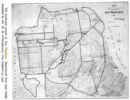
(Lewis, The Planning of A Modern City, a Review of the Principals Governing City Planning, p.139, 1916)
Just recently the City of Chicago nominated their boulevards to the National Register of Historic Places. In the nomination “fact form” the author argues that “Chicago’s park boulevard system was the first major comprehensive system in the country, and its design was seminal in the creation of such systems in cities nationwide.” (City of Chicago) Explaining why the boulevard system of the city was important, the author of the page writes that “The system’s boulevards and parks were created in the late 1800s to spur residential real-estate development and to help create healthful, accessible and livable neighborhoods in what was then the largely undeveloped outskirts of Chicago.” (cityofchicago.org) The suggestion that this boulevard system was designed to form specific parts of Chicago because they were under-developed leads us to question and wonder why these specific areas were part of the boulevard system of San Francisco.
A very interesting thing to note here, looking at the San Francisco map, and something we discussed in class is how Market Street runs on an angle from the other streets and avenues to its Northwest but runs parallel to the streets to its Southeast. Taken in the light of the idea of the Chicago city planning, it seems as though from the very beginning, the centralizing of Market street with the two distinct sets of grids points to strong intervention in planning to make Market Street the main road, rather than situations which allowed Market Street to become this city center. As with Chicago and the other cities know to use these boulevard systems, San Francisco used the planning and layouts of their cities and roads to form and shape the way the city and urban centers developed in the 20th century.
Much like in my last blog, I am fascinated to see the plethora of similarities of how San Francisco developed and grew (as well as how rapidly it did such compared to other major cities) when looking through the lens of a more American view of city building and forming as we see in other urban areas.
Sources:
“FACT SHEET National Register of Historic Places Nomination for the Chicago Park Boulevard System Historic District.” City of Chicago. N.p., 10 Aug. 2011. Web. 9 Sept. 2016.
Lewis, Nelson Peter. The Planning of the Modern City: A Review of the Principles Governing City Planning. N.p.: John Wiley & Sons, 1916. Print.
“Parks Boulevard Map.” City of Chicago. N.p., 2011. Web. 9 Sept. 2016.
Sewell, Jessica Ellen. Women and the Everyday City: Public Space in San Francisco, 1890-1915. Minneapolis: U of Minnesota, 2011. Amazon Kindle.
Tatum, Terry. “Chicago Park Boulevard System Historic District (cont.).” City of Chicago. N.p., n.d. Web. 09 Sept. 2016.
